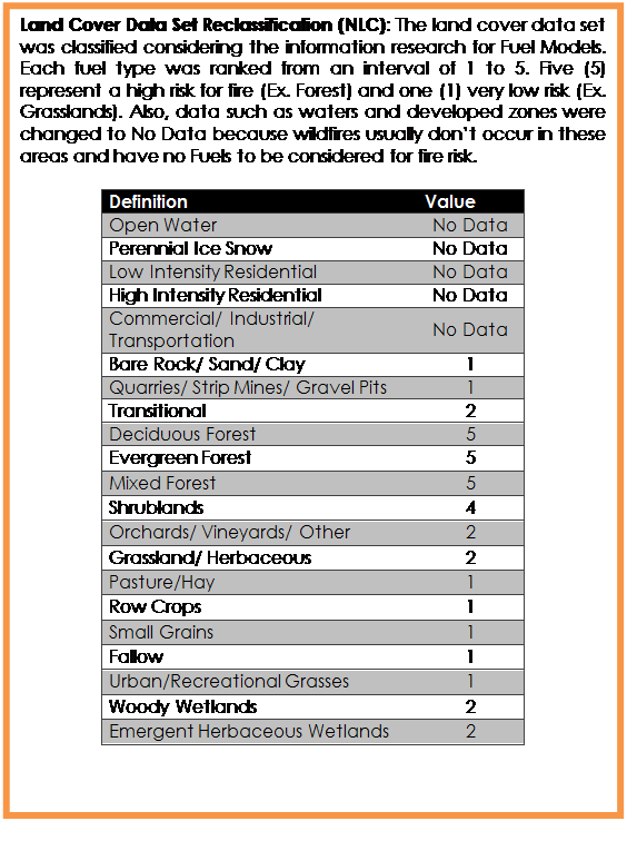
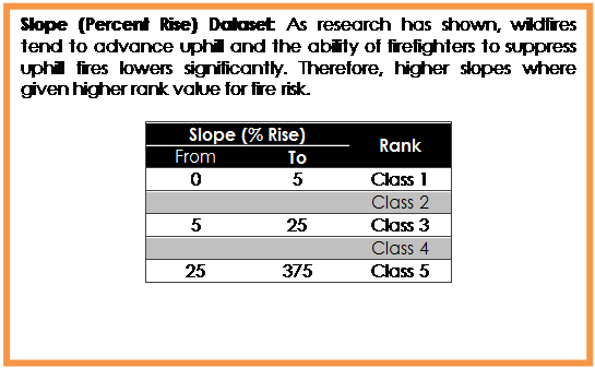
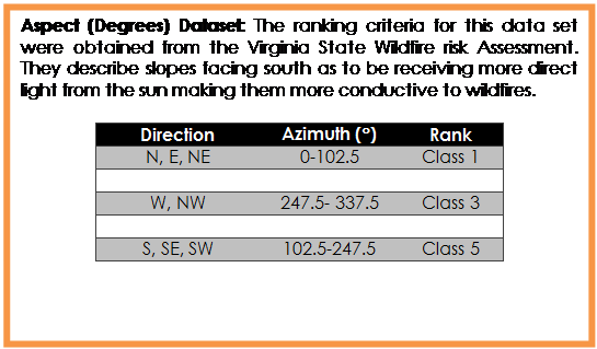
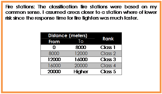
Return to project Main Page                                                                                                                                                                                                                                                                       Return to homepage

 
RANKING CRITERIA


Text Box: Land Cover Data Set Reclassification (NLC): The land cover data set was classified considering the information research for Fuel Models. Each fuel type was ranked from an interval of 1 to 5. Five (5) represent a high risk for fire (Ex. Forest) and one (1) very low risk (Ex. Grasslands). Also, data such as waters and developed zones were changed to No Data because wildfires usually don’t occur in these areas and have no Fuels to be considered for fire risk. 

Definition	Value
Open Water	No Data
Perennial Ice Snow	No Data
Low Intensity Residential	No Data
High Intensity Residential	No Data
Commercial/ Industrial/ Transportation	No Data
Bare Rock/ Sand/ Clay	1
Quarries/ Strip Mines/ Gravel Pits	1
Transitional	2
Deciduous Forest	5
Evergreen Forest	5
Mixed Forest	5
Shrublands	4
Orchards/ Vineyards/ Other	2
Grassland/ Herbaceous	2
Pasture/Hay	1
Row Crops	1
Small Grains	1
Fallow	1
Urban/Recreational Grasses	1
Woody Wetlands	2
Emergent Herbaceous Wetlands	2


Text Box: Slope (Percent Rise) Dataset: As research has shown, wildfires tend to advance uphill and the ability of firefighters to suppress uphill fires lowers significantly. Therefore, higher slopes where given higher rank value for fire risk. 

Slope (% Rise)	Rank
From	To	
0	5	Class 1
		Class 2
5	25	Class 3
		Class 4
25	375	Class 5
Text Box: Aspect (Degrees) Dataset: The ranking criteria for this data set were obtained from the Virginia State Wildfire risk Assessment. They describe slopes facing south as to be receiving more direct light from the sun making them more conductive to wildfires. 

Direction	Azimuth (°)	Rank
N, E, NE	0-102.5	Class 1
		
W, NW	247.5- 337.5	Class 3
		
S, SE, SW	102.5-247.5	Class 5
Text Box: Fire stations: The classification fire stations were based on my common sense. I assumed areas closer to a station where of lower risk since the response time for fire fighters was much faster.


Distance (meters)	Rank
From	To	
0	8000	Class 1
8000	12000	Class 2
12000	16000	Class 3
16000	20000	Class 4
20000	Higher	Class 5
Text Box: Flame Length:  Rate of Spread: The data set was readily available in RGIS website. The data set was readily available in RGIS website. As the metadata describes, the flame length is the distance from the base of the flame to the tip of the flame. It is an indicator of fire intensity. The classification method was obtained from the metadata, assuming that shorter flames are easier to suppress. 

Length (feet)	Rank
From	To	
0	1	Class 1
1	4	Class 2
4	8	Class 3
8	11	Class 4
11	Higher	Class 5
Text Box: Roads Layer:  The roads classification was based more on common sense. I assumed that areas bordering the roads had easy access for firefighter’s therefore lower fire risks.

Distance (meters)	Rank
From	To	
0	400	Class 1
400	1000	Class 2
1000	2000	Class 3
2000	5000	Class 4
5000	Higher	Class 5
Text Box: Ignition Probability: The data set was readily available in RGIS website. As the metadata describes, the raster gives values to areas where fires are likely to occur assuming that there will be an increase in probability of a fire occurring in areas where they have occurred in the past. The State Forestry procured the fire data from 1987 to 2008 and combined it into a density grid where each pixel represented a number of fires that have occurred per square kilometer. For reclassification purposes it was assumed that areas where the fire occurrences have been lower, there was less risk of a wildfires.

Probability 
(# fire occurrences per km2)	Rank
From	To	
1	2	Class 1
2	5	Class 2
5	10	Class 3
10	20	Class 4
20	37	Class 5
Text Box: 1.	Rate of Spread: The data set was readily available in RGIS website. The data set was readily available in RGIS website. As the metadata describes, the rate of spread represent the horizontal distance that a flame zone moves per unit of time. The classification method was obtained from the metadata, assuming that higher speeds increase the fire risk. 

Speed (ft./min)	Rank
From	To	
0	5.5	Class 1
		
5.5	55	Class 3
		
55	Higher	Class 5

Return to project Main Page                                                                                                       Back to top                                                                                                                         Return to homepage