GEOG585: Internet
Mapping: Home Work 2
Question 1
1. What request type is common across all three (WMS, WFS, WCS) OGC web services that
we have studied? GetCapabilities
Question 2
2. Answer the following questions about a WMS GetCapabilities request
2.1. What are the required parameters, and what do they represent?
REQUEST=GetCapabilities, tells the server the type of request.
SERVICE=WMS, tells the server this is a WMS request.
2.2. What is returned in response to a WMS GetCapabilities request?
The server returns a description of the available payloads from the
site. Contact info, layer names, etc.
Question 3
3. Answer the following questions about a WMS GetMap request
3.1. What are the required parameters, and what do they represent?
REQUEST=GetMap, Indentifies the type of request
VERSION, current version
LAYERS, list of layers to return to client
SRS, Spatial Reference System
BBOX, lower left and upper right corners of map area
WIDTH, width in pixels of map area
HEIGHT, height in pixels of map area
STYLES, applies layer style
FORMAT, type of file to return to client
3.2. What is returned in response to a WMS GetMap request? A raster
image
3.3. What is the significance of transparency in WMS requests? Having
background pixels transparent allows use of the layer as an overlay.
Question 4
4. What OGC request would you use to inform the configuration of a client application (like
ArcGIS) about an OGC service that you want to add layers from?
GetCapabilities will let a client application know what the server has to
offer.
Question 5
5. Which OGC request would you submit under the following circumstances
(include both the
service type [e.g. WMS, WFS, WCS], and the request [e.g. GetMap,
GetCapabilities,
GetCoverage, etc.] in your answer)
5.1. You want a map image representing three layers of data in a single JPEG
for a
specified area of interest. WMS, GetMap
5.2. You want to retrieve data representing geometries and associated
attributes for a road
network, with the returned data in GML. WFS, GetFeature
5.3. You want to retrieve data representing a digital elevation model (a
raster dataset) in the
form of a GeoTIFF. WCS, Get Coverage
Question 6
6. What are the EPSG codes of the following Spatial Reference Systems
6.1. WGS 84 (Geodetic CRS [geographic 2d]) EPSG::4326
6.2. NAD83 / UTM zone 13N EPSG::26913
6.3. NAD27 / UTM zone 13N EPSG::26713
Question 7
7. Use the proj utility to convert the following Geographic Coordinates into
UTM Zone 13,
NAD83 coordinates. Include your proj command and output in your writeup.
7.1. 33°40’38”N, 106°28’31”W (the Trinity Site)
proj +proj=utm +zone=13 +datum=NAD83 -r
33d40'38"N 106d28'31"W
363242.30 3727344.39
7.2. 35°47’18”N, 106°18’04”W (the Bandelier National Monument Historic Marker)
proj +proj=utm +zone=13 +datum=NAD83 -r
35d47'18"N 106d18'04"W
382418.16 3961252.75
Question 8
8. Retrieve the GetCapabilities XML response from the following WMS, and
answer the
following
questions. http://gstore.unm.edu/apps/rgis/datasets/100157/services/ogc/wms?VERSION=1.1.1&SERVICE=WMS&REQUEST=GetCapabilities
8.1. What is the Title of the service? RGIS Dataset
8.2. Who is the Contact Person for questions about the service?
Renzo
8.3. What are the available image formats for the GetMap request for this
service? jpg, png, gif, 24bit png, vnd.wap.wbmp, tiff, svg+xml
8.4. What are the SRS/CRS’s for which layers from this service are available
(remember
that nested layers inherit the SRS/CRS of their parent layers).
EPSG:4326, EPSG:4269, EPSG:4267, EPSG:26913, EPSG:26912, EPSG:26914, EPSG:26712,
EPSG:26713, EPSG:26714
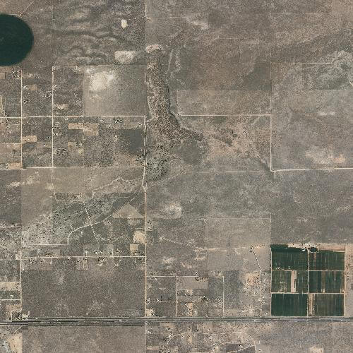
8.5. Formulate a GetMap request for the “naip2009rtindex_idx” and
“naip2009rtindex” layers from this service, for a 500x500 pixel map image that
is 0.05-
degrees wide, with the SW corner of the map image located at 35°N and -106°E.
Include in your write-up the complete GetMap request and the returned map image.
http://gstore.unm.edu/apps/rgis/datasets/100157/services/ogc/wms?VERSION=1.1.1&REQUEST=GetMap&SERVICE=WMS&LAYERS=naip2009rtindex_idx,naip2009rtindex&STYLES=&BBOX=-106,35,-105.95,35.05&WIDTH=500&HEIGHT=500&SRS=EPSG:4326&FORMAT=image/jpeg
|