Introduction
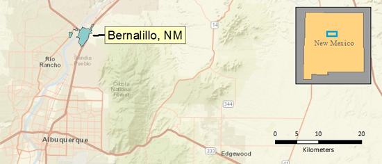
Bernalillo, NM is a small town located about 15 kilometers north of Albuquerque. Much of the town’s area falls under a Special Flood Hazard Area (SFHA) . These are designated by the Federal Emergency Management Agency (FEMA) as areas that will be inundated by floodwaters of the base flood, or the 100 year flood. The areas are published on Flood Insurance Rate Maps (FIRMs). Buildings and homes that fall within a SFHA and have a federally-backed mortgage are required to purchase flood insurance. Residents near the east bank the Rio Grande were until recently not within a SFHA, as they were protected by a spoil bank levee. In 2008, this levee was decertified by FEMA, and many of these residents were forced to pay for flood insurance. Required flood insurance is a significant cost for the community, but due to the high cost of building the levee to new standards, and the relatively low property volume and value that is affected, its reconstruction is unlikely. Other towns along the Rio Grande are experiencing similar situations.
Objective
The purpose of this project is to estimate the property value that falls within SFHAs along the Rio Grande that could be or is protected by a certified levee. Based on areas which do have a certified levee in place, such as in Albuquerque, a benchmark for the value that economically justifies the construction of a levee can be inferred. To do this, a metric of affected property value in dollars per unit length of levee will be calculated. This will be used to compare Bernalillo and other populated areas along the length of the Rio Grande.
Data Sources
National Flood Hazard Layer | Flood Insurance Rate Maps | 2010 US Census 2011 | American Community Survey
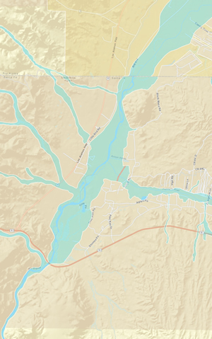
Area of Study
Method
In order to work only with hazard areas that could potentially be levee protected, SFHAs that pertained to Rio Grande overbank flood were isolated from the National Flood Hazard Layer. The layer was cut to areas along the river, and runoff/arroyo-based flood areas were removed for the length of the study area.
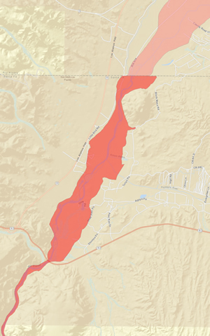
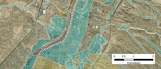
Isolating Rio Grande overbank flood zones in the National Flood Hazard Layer (NFHL)
The working SFHA layer was intersected with 2010 census data. For block groups that fell partially along the edges of the SFHA, housing count was calculated proportionally by the area that fell within the SFHA. The housing blocks within the SFHA were then spatially joined with the ACS 5-yr survey data, to acquire average home value data. This allowed for the estimation of total home value within each block group.
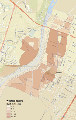
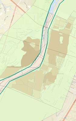
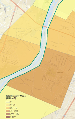
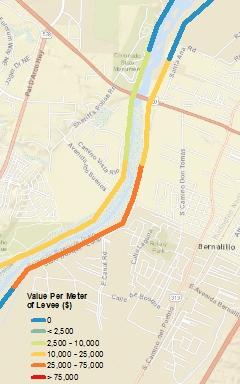
A hypothetical length of levees was digitized for the length of the study area. The levees were broken into segments which corresponded with town and major SFHA boundaries. Polygon areas were created adjacent to the levee and surrounding the SFHA block groups. Data from the block groups was transferred to these polygons using the Intersect and Dissolve tools, and then transferred to the levee segments using Identity. Property value per meter length of levee can then be calculated. Bernalillo is used for the example of the method below.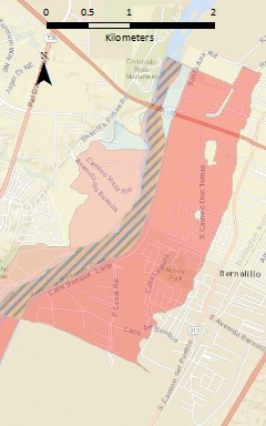
![]()
![]()
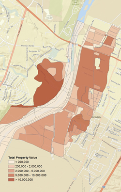
SFHA > Intersected with 2010 Census Data > Spatially joined with ACS 5yr data, and values calculated
![]()
![]()
Hypothetical levees and data collection areas (DCA) > Data aggregated to DCAs > Identity tool with levees
Results
Areas along the Rio Grande can now be compared:
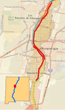
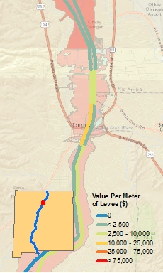
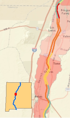
Property Value per Meter Length of Levee for Albuquerque, Espanola, and Los Lunas / Belen
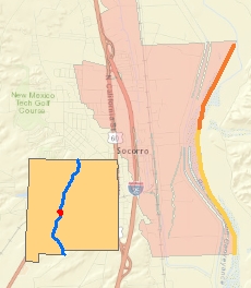
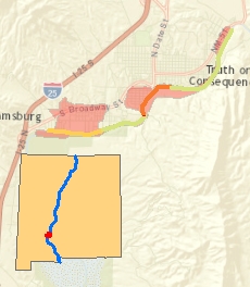
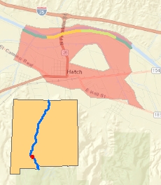
Socorro, Truth or Consequences, and Hatch
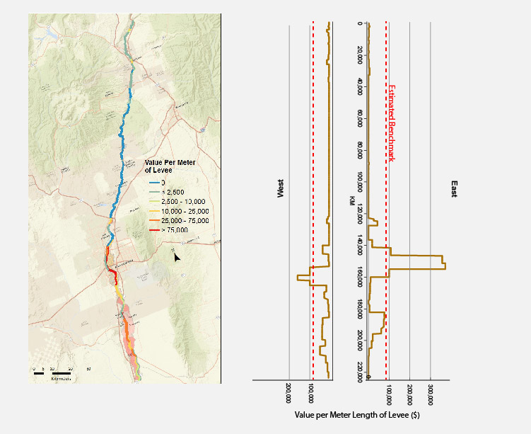
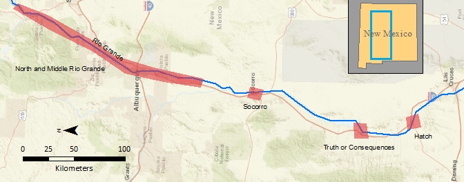
Northern and Middle Rio Grande
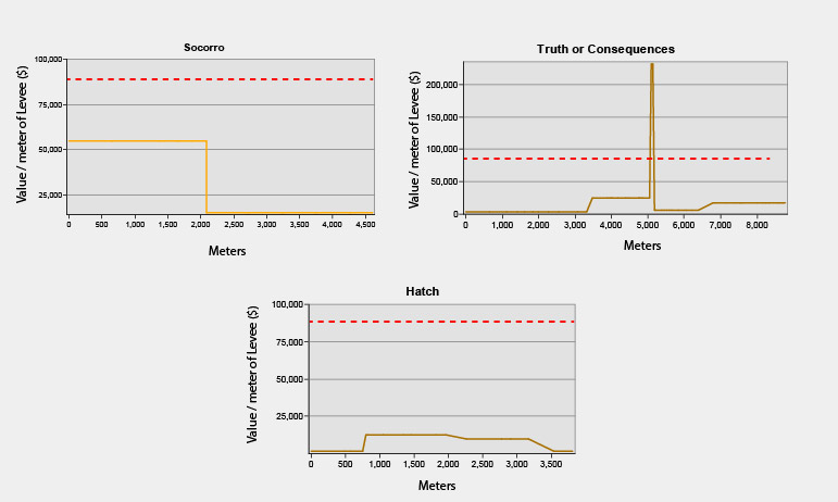
Value per Meter Length of Levee for Socorro, T or C, and Hatch
Conclusions
Comparisons of the property value per unit length of levee metric between areas along the Rio Grande show that many are in similar circumstances as Bernalillo: their affected property value seems to be too low relative to their length of necessary levee to justify the construction or re-engineering of levees to FEMA’s new standards. It is clear that a major city such as Albuquerque necessitates a certified levee, but what is less clear is at which point a populated area reaches this point. The areas with the highest property values but still without a certified levee are the towns south of Albuquerque, such as Belen and Las Lunas.
It must be made clear, however, that there are many considerations besides property value that are included in the decision to construct a levee. Factors such as political considerations, cultural importance, historical significance, cost of construction, and availability of funds are also included. For example, even though Hatch, NM has a very low value per unit length of levee for it’s affected area, the city recently completed a re-engineered levee that is currently awaiting certification by FEMA (IBWC.gov). This may be due in part to the fact that FEMA is updating the FIRMs for this area, to be released in the next several years. FEMA is currently reviewing and updating FIRMs for other areas as well, and these areas will most likely re-evaluate their levee needs accordingly. Hatch also has tremendous economic value and is a state cultural landmark.
The metric created in this project is also limited in its scope. It doesn’t take into account agriculture (much of the area directly bordering the Rio Grande is family farms), commercial buildings, or distinguish between different risk levels. There is also sizeable error involved the calculations. The average home value estimates from the ACS 5-year survey have as much as 40% error in some cases. As well, each time a value or housing amount is calculated by proportional area, some loss of accuracy occurs.
Because of these considerations, the metric, while good for comparing general value across large areas, should not be used by itself to assess the justifiability of a levee. Detailed local analysis on a case by case basis would be needed.