


|
|
|
|
|
|
|
|||
Detecting Neogene uplift along the Jemez lineament with GIS > Background
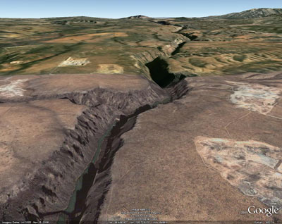
This is the 800 foot deep Taos Gorge in northern New Mexico. Traditionally we see deep canyons like this resulting from climate or geomorphic influences such as the river cutting through hard bedrock. My project attempts to quantify the impact of underlying tectonic uplift on river insicion for drainage basins crossing the Jemez lineament. Google Earth view of Taos Gorge |
 |
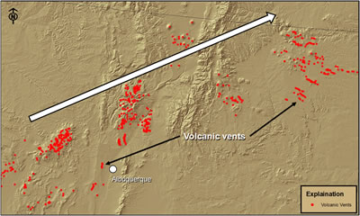
The Jemez lineament is a NE trending topographic feature defined by volcanic vents extending from the Arizona/New Mexico border to the Colorado/New Mexico border. Recent volcanic events along the lineament include supervolcanic eruptions of the Valles Caldera 1.2 and 1.6 million years ago (Ma).
|
 |
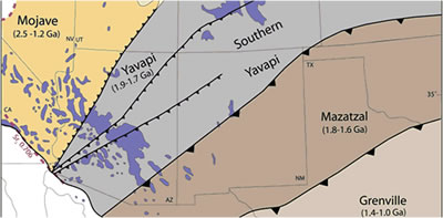
History of the lineament: Roughly 1.8 billion years ago (Ga), the Yavapai and Mazatzal provinces collided creating a suture zone the resulted in a weakness at the boundary. Periodic tectonism has prevented this suture from healing completely.
|
 Karlstrom and Humphreys 1998 Karlstrom and Humphreys 1998 |
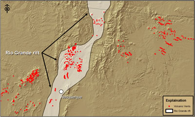
Continental rifting beginning approximately 70 Ma, now known as the Rio Grande rift, help re-activate the suture allowing an efficient path for magmas to reach the surface.
|
 |
| Project Home | Next > |
Background |
Analysis | Results | Future Work |